
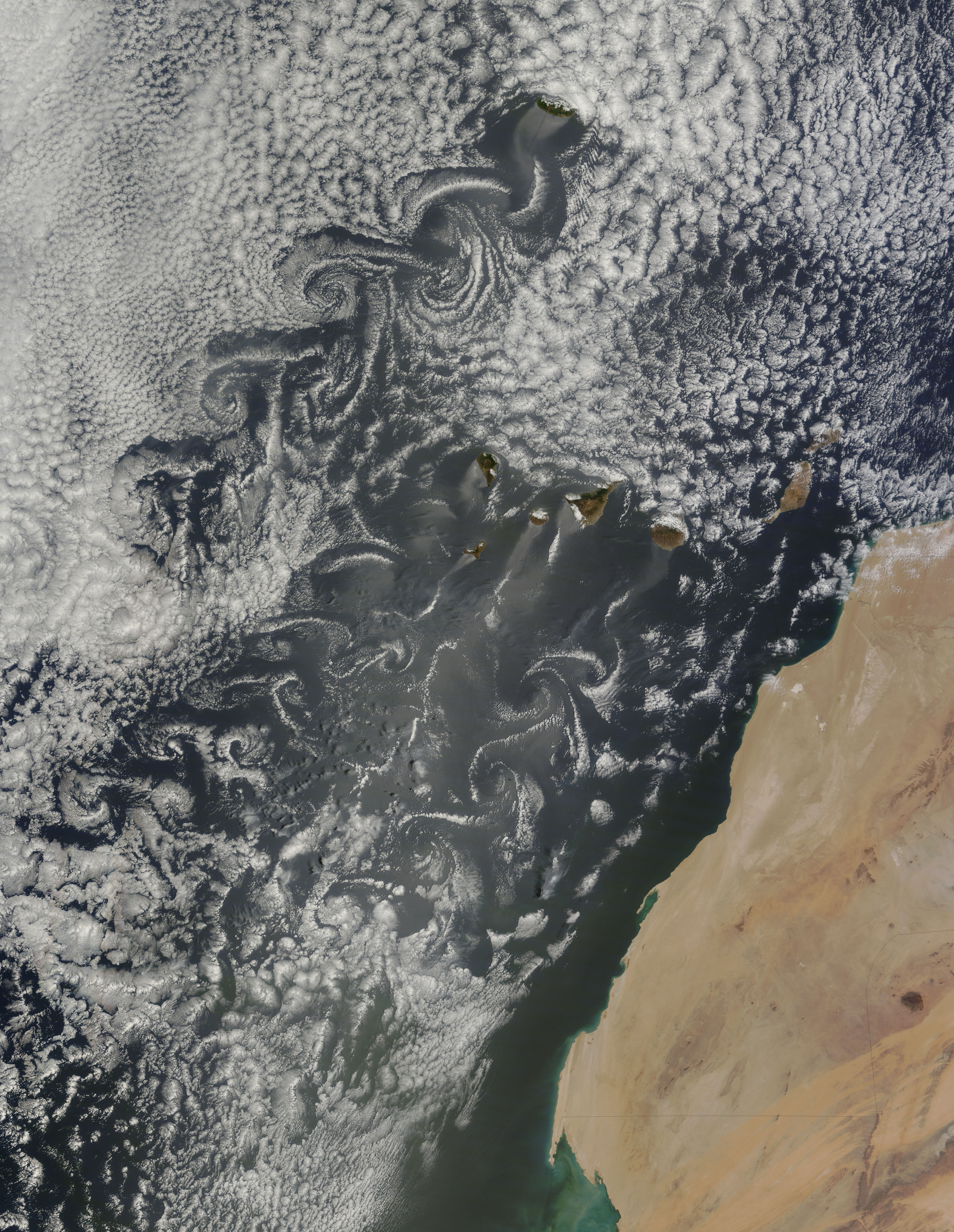
1. Three trails of clouds over the sea
The image shows a cloud-covered sea, islands exposed between clouds, and the northwest African coast on the right. Following the winding bands behind the islands reveals three trails with alternating rounded curls. This is the area around the Canary Islands and Madeira observed by MODIS aboard NASA’s Terra satellite on May 20, 2015. What you see is not swirling seawater but cloud patterns shaped by moving air. Distinguishing water from air is the starting point for reading the image correctly.
Examine separately the curved trail starting from the large cloud gap near the top and the long trails below the central islands. Each trail is more than a white line of uniform width. Bright places where clouds gather and dark places where fewer clouds expose the sea curve together. NASA describes three distinct vortex streams in this scene. This does not mean every small cloud fragment is a separate vortex, and this article does not turn the number of curls into a wind-speed measurement.
2. How does an island obstruct the wind?
When air meets a tall island, the terrain disturbs its original flow. Mountains rising above the surrounding sea are obstacles that wind must go around or over. On the downstream, or leeward, side, rotating flows of air can detach successively and form a trail. Such a repeating vortex arrangement is called a von Kármán vortex street. Rather than imagining the island pushing clouds directly into a long line, read the cloud distribution as revealing air flow altered by the island.
Small eddies behind a boulder in a river offer a helpful analogy for an obstacle and its downstream wake. But the scale of the atmosphere over the sea and the conditions in river flow are not identical. Air is invisible and clouds are not fixed objects, so the image is not a diagram laying out the complete flow. The analogy explains only that a rock or island can change the flow behind it. It must not be used to insert river-eddy dimensions into the photograph and calculate cloud height or air speed.
3. Why do the curls alternate?
A defining feature of a von Kármán vortex street is that vortices rotating in opposite directions alternate along the two sides of the flow. This differs from an entire trail moving around one giant circle. From a distance the curved bands look wavelike, while closer inspection reveals staggered curls and dark gaps. NASA explains that disturbance passing the high terrain propagates downstream and produces vortices with alternating rotation. This arrangement helps distinguish the image from a simple cloud band.
Following curves in a still image with your eyes does not directly measure the actual rotation of every curl. Clouds can change shape and overlap, and part of a curl can be hidden by the cloud layer. Separate the mechanism described in the observation account from the forms visible in one frame. For example, the alternating arrangement can be observed here, but one frame cannot show where a particular cloud moved over several minutes. Confirming motion requires a sequence acquired at different times.
4. White clouds are not the wind itself
Clouds consist of tiny water droplets or ice particles; wind is the motion of air. Cloud patterns therefore offer clues to air flow but are not identical to the entire wind field. Even if air rotates, it may not show the same pattern in visible satellite imagery when conditions do not let clouds reveal it. Conversely, dark cloud gaps form the pattern together with bright neighboring clouds, so reading only the white parts can miss the vortex shape. There is no reason to interpret the dark gaps as giant holes beneath clouds or drains in the sea.
Cloud brightness is not an air-speed gauge either. You can compare whiter and darker places in this image, but brightness alone cannot establish numerical wind speeds or upward and downward velocities. The observed wavelengths, cloud properties, viewing direction and image processing also affect its appearance. This article uses a NASA-distributed JPEG based on observations, not a raw numerical file transmitted by the sensor. Avoiding invented band combinations or color-correction procedures that the source does not disclose is part of describing the image accurately.
5. The same island does not produce the same pattern every day
Even when island terrain stays the same, wind direction and strength and the conditions for cloud formation change. NOAA explains that changes in prevailing winds can alter vortex direction and structure. One striking arrangement should therefore not be treated as an island’s fixed daily pattern. This is why the observation date matters. Publication and acquisition dates differ, and a 2015 observation cannot describe today’s winds or the current sky at a travel destination.
Comparing satellite images from several times helps reveal cloud motion and change. NOAA distinguishes the roles of geostationary observation, which keeps watching the same region, and satellites that travel around Earth to observe it. That does not justify joining images from different dates or islands as though they were the next frames of this scene. Check location, time and sensor before comparing. The main image here is one Terra MODIS observation scene, not an animation of vortex motion assembled across times.
6. A sequence for reading your next satellite image
For a similar image, first find the coast and islands, then follow cloud trails beginning behind the terrain. Look for alternating curls and for gaps with fewer clouds curving in the same direction to build evidence for a description of the shape. Not every long cloud formation is a von Kármán vortex street. Record the visible differences between orderly parallel cloud rows and spiral arrays first. Reading place names together with the observing institution’s explanation also reduces confusion between similar-looking phenomena.
Finally, check the acquisition date, instrument, distribution source and exact file used. Here the NASA-supplied 4800×6200 pixel JPEG is used without further cropping or color changes. The white cloud curls, dark sea gaps and relative positions of islands and coast match the features discussed in the text. Showing atmospheric flow is different from claiming that a single image can precisely measure wind speed or altitude. Recording both the visible pattern and what it can tell you helps in reading satellite images.