
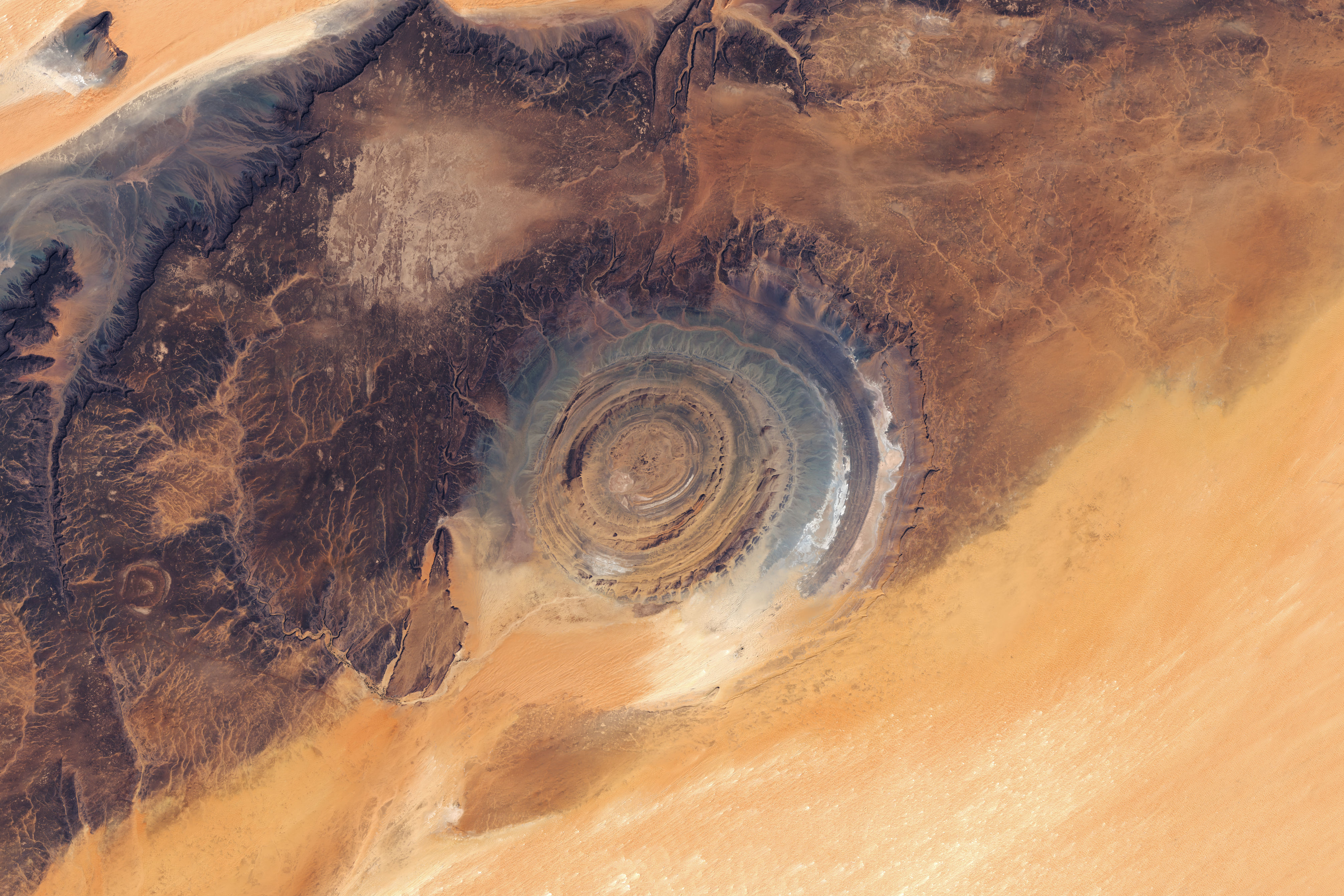
1. Nested rings that stand out in the desert
Nested gray and brown rings amid ocher sand catch the eye. The central Richat Structure is a geological feature on the Adrar Plateau in Mauritania, northwestern Africa. This NASA image is a mosaic joining Landsat 9 observations from March 5 and Landsat 8 observations from March 6, 2026. An overhead view reveals a structure about 40 kilometers across, nicknamed the Eye of the Sahara. Eye is a metaphor for its shape, not a photograph of an eyeball or an artificial target.
Broadly divide the image into central concentric ridges, dark plateau above and on the left, and bright sand spreading below and to the right. Branching dry channels also appear on the left. Following the rings shows breaks and curves rather than only perfectly smooth circles. Including this surrounding terrain changes the impression produced by cropping out just the round pattern. The article concerns that actual landscape, not a circular diagram drawn on sand or an imagined reconstruction.
2. Erosion exposes the rings of uplifted layers
The key to understanding Richat is that rock layers rose into a dome and were then deeply eroded over time. NASA’s recent account relates the uplift forming this geological dome to an underground intrusion of igneous material. When layers bend upward, different rock units can appear at the surface in ways unlike layers lying side by side in one flat plane. As the top is eroded, traces of different layers become exposed inward and outward. Dome here describes the structure’s formation and erosion, not a smooth hemispherical mountain still standing at the center.
Not all rocks erode at the same rate. More resistant layers can remain as ridges, while more easily eroded parts form lower ground between them. Combined with the arrangement of previously curved layers, this differential erosion emphasizes nearly concentric ridges. This differs from immediately interpreting a ring as an ancient wave mark or an embankment piled from sand. Linking ring outlines to rock-layer arrangement shows that erosion not only removes material but can expose an internal structure at the surface.
3. Not every round feature is an impact crater
Richat was once interpreted as a possible meteorite impact feature. Circular forms are common among impact craters on Earth and other worlds, so the background to that hypothesis is understandable. But a round outline does not establish a formation process. Current NASA and U.S. Geological Survey accounts explain it through geological uplift and erosion. The International Union of Geological Sciences’ geoheritage description likewise treats it as a magma-related concentric structure. This article focuses on what observations distinguish explanations rather than on a story about a falling meteorite.
Satellite imagery shows the broad rings and their surroundings together, but a single image does not measure all rock properties or subsurface structure. Explaining origins also requires field geology, rock studies and information on the underground structure. A sharp image cannot replace all that research. Separate the observation of roundness in this image from the interpretation of dome uplift and erosion supported by studies. Avoiding identical names and histories for two similar shapes is also useful when viewing other planets.
4. Distinguish rock color from terrain height
Orange and grayish bands contrast in the image. NASA connects these tonal differences with different sedimentary and igneous rock types across the structure and its surroundings. That does not mean every gray area is the same rock or every orange area the same age. No key in this image mechanically pairs each color with a rock name. First examine ring and plateau forms, then supplement judgments about rock types with the observing institution’s description and geological information.
Brightness should not be converted into height either. Bright sand and dark plateau appearing together do not let you calculate the terrain elevation of every pixel. The main image is a mosaic based on optical observations, not an elevation map or three-dimensional terrain model in which color means height. Distinguish rock and sand distribution, surface conditions, and methods of observation and presentation. Enjoying the eye-like contrast and numerically measuring each ring’s height or depth require different data and procedures.
5. What a two-date mosaic tells us
This is not described as a single photograph taken at one instant because its source specifies two dates. It uses Landsat 9 data from March 5 and Landsat 8 data from March 6. A mosaic joins an area of interest into a broader view; including different days does not make the terrain imaginary. But calling it one exposure or one pass by one satellite would also be wrong. State both its observational nature and how the released image was assembled.
When comparing other Richat images, check dates, instruments, coverage and color rendition for each scene. The U.S. Geological Survey also provides natural-color composites from other times and mosaics joining several images of this region. They are not all originals from the same day or simply larger or smaller copies of this image. If published diameter figures vary slightly, first consider where each source places the boundary. This article uses the approximately 40 kilometer extent in the selected NASA account rather than mixing maximum values into a new size record.
6. Read beyond the rings for the landscape’s context
Return to the photograph and move outward from the central rings toward the plateau and bright sand. Dark rocky terrain, branching channels and sand-covered areas continue beyond the rings. Richat can be read as part of a wider surface rather than an isolated circular hole. You can also ask whether a visible boundary marks a rock-layer contact or the edge of a sand cover. Even when a photograph cannot settle the answer, recording form and color separately and comparing geological information makes an initial impression more specific.
This site uses NASA’s distributed 4022×2681 pixel JPEG without further cropping or color changes. Descriptions of rings, dark plateau and bright sand correspond to the actual scene in this file. Checking the original source, both acquisition dates, the mosaic format and the explanation of rock layers and erosion reduces the temptation to infer a meteorite or artificial structure solely from roundness. First describe the visible terrain, then distinguish what research supports about its formation. Reading the surrounding environment beyond the rings makes its clues more concrete.